Eighteen Islamabad Map: Location, Access & Key Distances
Quick answer: The Eighteen Islamabad Map confirms the society sits on Srinagar Highway in Sector H-17, approximately 10 to 15 minutes from New Islamabad International Airport and 3 to 4 minutes from the M-2 Motorway Toll Plaza positioning it as one of Islamabad’s most transit-efficient premium developments.
Eighteen Islamabad’s location is a strategic advantage, not just a selling point. Most location guides give you a vague neighborhood name and call it done. No distances. No drive times. No usable directions. The Eighteen Islamabad Map guide you’re reading right now is different exact distances, confirmed access routes, verified drive times, and a clear master plan breakdown. Nothing more, nothing less. For a full overview of the project developer background, NOC status, and master plan see ourcomplete Eighteen Islamabad guide.
Eighteen Islamabad Map & Master Plan Layout
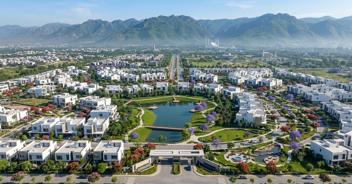
The Eighteen Islamabad Map places the society directly on Srinagar Highway, within Sector H-17 on Islamabad’s western corridor. The project spans approximately 572 acres and is developed in collaboration with the IDG Group (International Golf Development) the same group behind golf communities across the Middle East and Southeast Asia.
Here’s how the master plan breaks down functionally:
- Residential Villas: Low-density villa clusters spread across landscaped sectors, accessible via internal link roads from the Srinagar Highway entrance gates
- The Heights: Pavilion-style apartment towers positioned toward the commercial front of the development
- The Core: A dedicated commercial business district serving both residents and the wider western zone
- 18-Hole IDG Golf Course: The anchor feature occupying a significant portion of the interior layout, defining the community’s open-space footprint
For orientation, Eighteen Islamabad sits west of H-12 and H-17 sectors, with the Tarnol link road to its northwest. Readers familiar with western Islamabad’s grid will recognize this zone as the buffer between the capital’s organized sector layout and the New Islamabad Airport corridor.
The Western Corridor Transit Rule: Eighteen Islamabad’s valuation is structurally tied to its placement on the capital’s western transit axis. Because the master plan sits directly on Srinagar Highway adjacent to the M-1 and M-2 Motorway link road, it intercepts inbound airport traffic before it reaches the denser city center. This positioning compresses drive times to New Islamabad International Airport to under 15 minutes while maintaining a direct, signal-free route into central Islamabad.

Access via Srinagar Highway
Srinagar Highway is Eighteen Islamabad’s primary access artery and the most direct route for the majority of Islamabad residents.
Traveling west from Zero Point, take Srinagar Highway past the G-13 and G-14 sector exits. Continue along the signal-free corridor past the Koral Interchange. The Eighteen Islamabad entrance gates front directly onto Srinagar Highway you will not need to exit onto internal sector roads.
Key distance benchmarks from Srinagar Highway reference points:
- From Zero Point: Approximately 20 to 25 minutes traveling west on a signal-free corridor
- From Faizabad Interchange: Approximately 18 to 22 minutes
- From G-13 sector exit: Approximately 8 to 10 minutes
Srinagar Highway connects Islamabad’s northern administrative zones, embassies, and F-sector commercial hubs directly to the western corridor. For residents commuting into the city, this highway eliminates the grid-lock of internal sector crossings.
⚠️THE SRINAGAR HIGHWAY NAMING MANDATE:
Investors and overseas buyers using legacy maps or older GPS software must note that the primary access artery, formerly known as Kashmir Highway, was officially renamed to Srinagar Highway. Eighteen Islamabad’s primary access gates sit directly on this highway. Do not confuse the main access grid with internal sector link roads the direct highway frontage is what guarantees the society’s high-velocity commercial and residential transit.
For a deeper breakdown of interchange logistics, cross-reference the Nearest Motorway Interchange content on Properties Corner.
Access via Kashmir Highway
Kashmir Highway functions as the parallel eastern corridor the route of choice for travelers arriving from Rawalpindi or from Islamabad’s G-sector zones.
The operational distinction is straightforward: Kashmir Highway connects through the Islamabad Expressway and the Kashmir Highway Extension, merging traffic from Rawalpindi’s GT Road intersection into the broader western sector grid before linking to Srinagar Highway.
Practical drive times from Kashmir Highway reference points:
- From Rawalpindi’s Saddar: Approximately 30 to 35 minutes via GT Road onto Kashmir Highway
- From Faizabad Interchange: Approximately 22 to 27 minutes via the Kashmir Highway–Expressway corridor
- From Committee Chowk, Rawalpindi: Approximately 28 to 33 minutes
Which route is faster? If your origin point is central Islamabad or any F/G sector location, Srinagar Highway is the faster option by 5 to 8 minutes. If you’re traveling from Rawalpindi Saddar, Committee Chowk, or GT Road the Kashmir Highway corridor is the more direct approach.
Road infrastructure on both arteries is well-maintained. Srinagar Highway’s signal-free stretches give it a predictable commute window; Kashmir Highway sees heavier freight traffic during morning hours near the Faizabad zone.
Distance from New Islamabad Airport & M-2 Motorway
These are the two data points that matter most to investors evaluating Eighteen Islamabad against Islamabad’s wider premium society landscape.
New Islamabad International Airport: Approximately 10 to 15 minutes of driving time via the airport link road, depending on time-of-day traffic. This proximity creates a highly liquid rental catchment; aviation professionals, international corporate executives, and diplomatic staff represent a consistent, high-income tenant pool for villa and apartment investors.
M-2 Motorway (Islamabad–Lahore): Approximately 3 to 4 minutes from the Islamabad Toll Plaza, accessible via the dedicated M-1/M-2 link road. For investors tracking inter-city connectivity, this places Eighteen Islamabad at a decisive logistical advantage over societies positioned deeper within Islamabad’s eastern or southern sectors.
The Western Corridor Transit Rule (Applied): The M-2 on-ramp is 3 to 4 minutes away. The airport is under 15 minutes. These are not amenity highlights they are commuter metrics that buyers can verify, compare, and return to when evaluating entry price against long-term rental yield.
Want to see the site yourself?Contact Properties Corner to schedule a visit to Eighteen Islamabad.
Distance from Zero Point & Twin Cities Connectivity
Zero Point is Islamabad’s standard geographic benchmark the reference point buyers and analysts use when comparing societies across the capital’s concentric sector grid.
From Zero Point,Eighteen Islamabad is approximately 20 to 25 minutes of direct driving time, traveling west along Srinagar Highway’s signal-free corridor. That distance places it firmly within the practical commute range of Islamabad’s F-sector offices, Blue Area commercial district, and G-sector government zones.
Twin Cities connectivity expands the picture further:
- Rawalpindi’s Saddar: Approximately 30 to 35 minutes via Kashmir Highway
- Faizabad Interchange: Approximately 18 to 22 minutes via Srinagar Highway
- Committee Chowk: Approximately 28 to 33 minutes
How does this compare to similar premium societies? TheMulti Garden B-17 Map guide andFaisal Hills Map offer a direct connectivity comparison across Islamabad’s premium tier. B-17 sits further into the northern sector grid, adding 5 to 10 minutes to airport and motorway access.Faisal Hills, positioned along the GT Road corridor near Taxila, trades proximity to Islamabad’s core for deeper Rawalpindi connectivity.
Eighteen Islamabad sits at the intersection of both markets accessible to Islamabad’s professional core and Rawalpindi’s commercial base without being locked into either grid.
That’s not a coincidence. It’s a location decision that compounds in value over time.
Nearby Amenities & Surrounding Infrastructure
Within practical reach of Eighteen Islamabad:
- Healthcare: Quaid-e-Azam International Hospital approximately 14 minutes
- Education: FAST NUCES, Riphah International University, Roots Millennium School within a 15 to 20-minute radius
- Neighboring Societies: TopCity-1, Mumtaz City, University Town all within the western corridor zone
- Commercial Hubs: Blue Area and F-sector commercial zones accessible within 20 to 25 minutes via Srinagar Highway
- Retail: Centaurus Mall and Giga Mall approximately 22 to 28 minutes via the highway corridor
This section is intentionally concise. Amenities confirm the surrounding infrastructure is functional the transit data is what determines investment logic.
Location as Investment Logic
Pull back and look at the full picture. TheEighteen Islamabad Map confirms four data points that matter to any serious buyer or investor:
- Airport distance: 10 to 15 minutes the strongest proximity metric of any comparable western-zone society
- Motorway access: 3 to 4 minutes to the M-2 Toll Plaza direct inter-city connectivity without navigating Islamabad’s internal grid
- Zero Point drive time: 20 to 25 minutes along a signal-free corridor within the acceptable commute window for capital professionals
- Dual highway access: Srinagar Highway as the primary artery, Kashmir Highway as the Rawalpindi-facing alternative
These are not selling features. They are verifiable infrastructure fundamentals that buyers can confirm on any mapping platform, revisit at any point, and compare objectively against competing societies. Premium entry price is justified when the location data holds and the Eighteen Islamabad Map data holds.
For developer background, NOC status, and full project overview, return to ourcomplete Eighteen Islamabad guide. Once the location checks out, the next question is costsee current Eighteen Islamabad payment plans.Explore Eighteen Islamabad villa options once you’ve confirmed the location fits your needs.
Ready to evaluate Eighteen Islamabad as your next investment?Contact Properties Corner for verified listings and a guided site visit.
Frequently Asked Questions
Where exactly is Eighteen Islamabad located?
Eighteen Islamabad is situated on Srinagar Highway in Sector H-17, adjacent to the M-1 and M-2 Motorway junction in Islamabad. The society’s primary entrance gates front directly onto Srinagar Highway, placing it on Islamabad’s western transit corridor.
How far is Eighteen Islamabad from New Islamabad Airport?
The society is approximately a 10 to 15-minute drive from New Islamabad International Airport via the airport link road. This proximity makes it one of the most airport-accessible premium residential addresses in the capital.
How do I access Eighteen Islamabad from the M-2 Motorway?
Eighteen Islamabad is accessible within 3 to 4 minutes from the Islamabad Toll Plaza using the dedicated M-1/M-2 link road. Turn onto Srinagar Highway heading east from the toll plaza, and the society entrance is directly on the highway.
Is Eighteen Islamabad accessible via Srinagar Highway?
Yes. Eighteen Islamabad’s primary access gate fronts directly onto Srinagar Highway, previously known as Kashmir Highway. Buyers using older GPS software should update their maps to reflect the official highway renaming to avoid navigation errors.
How far is Eighteen Islamabad from Zero Point?
Eighteen Islamabad is roughly a 20 to 25-minute drive west from Zero Point along Srinagar Highway’s signal-free corridor. This places it within standard commute range for professionals working in Islamabad’s F-sector offices and Blue Area commercial district.