
Faisal Hills Map 2026: All 7 Blocks, Master Plan & Location
Updated October 2026
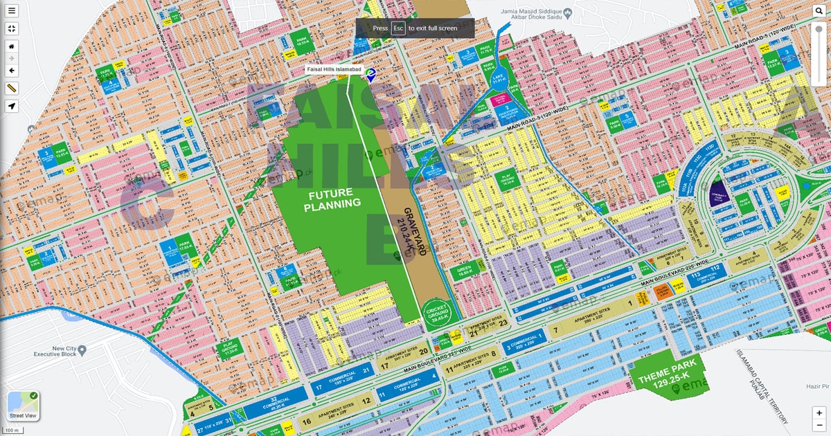
Quick answer: Faisal Hills is an RDA-approved housing scheme by Faisal Town Group (Zedem International) on the main GT Road (N-5) near the Taxila Bypass. It covers about 11,823 kanals and, according to the current master plan, is divided into seven blocks: Executive, Prime, A, B, B Extension, C and D. Plot sizes range from 5 marla to 2 kanal. The map below shows how the blocks connect through a 225-foot main boulevard.
A map is the fastest way to judge a plot before you spend money. It shows how far a block is from the GT Road entrance, which blocks sit near commercial areas, and where the parks and wide roads are. This guide walks through the Faisal Hills map block by block, so you can match a block to your budget and plans.
If you are still comparing options, start with our Faisal Hills overview page. For prices and available inventory, see the Faisal Hills plot for sale guide.
Faisal Hills Master Plan Map
The master plan shows a large, planned community built around a wide central boulevard. The developer cites the main boulevard at 225 feet, and internal roads run from about 40 to 120 feet depending on the block. Green belts, parks, mosques, schools and commercial strips are spread across the scheme, so no single block carries all the traffic or all the shops.
Maps are updated by the developer from time to time. Always check the latest approved layout with the developer or RDA before you pay for a plot.
Faisal Hills at a Glance
| Detail | Information |
| Developer | Faisal Town Group (Zedem International) |
| Approval | RDA-approved. Confirm the current NOC status before buying. |
| Total area | About 11,823 kanals |
| Location | Main GT Road (N-5), near the Taxila Bypass |
| Blocks | Executive, Prime, A, B, B Extension, C, D |
| Plot sizes | 5 marla to 2 kanal (varies by block) |
| Main boulevard | About 225 feet wide (developer figure) |
| Internal roads | About 40 to 120 feet |
| Landmarks | Arc Monument, Faisal Jewel, Hill Walk Downtown, Roots International School |
Faisal Hills Location on the Map
Faisal Hills sits on the Grand Trunk Road near Taxila, with the Margalla Hills as its backdrop. The Executive Block faces GT Road and forms the main entrance, which gives the scheme strong road visibility.
How to find Faisal Hills on Google Maps
Open Google Maps and search for “Faisal Hills Taxila” or “Faisal Hills Islamabad”. Both bring up the society on the N-5 near the Taxila Bypass. Switch to satellite view to see the boulevard and the blocks that are already built up. For a specific plot, use the block map below, because Google Maps does not show individual plot numbers.
Distances and connectivity
- Motorways: Close access to the M-1 (Peshawar-Islamabad) and M-2 (Lahore-Islamabad) motorways and the M-14 route, as well as the main GT Road.
- Islamabad: Roughly 40 to 50 minutes to central Islamabad (for example F-10 or the Blue Area), depending on traffic and route.
- New Islamabad International Airport: About 45 minutes by road in normal traffic.
- Nearby places: Taxila city and museum, HITEC University Taxila, and the B-17 corridor, including B-17 Islamabad.
Travel times change with traffic and road works. Check the route in Google Maps before you plan around a specific time.
Faisal Hills Block Map: All 7 Blocks Explained
Each block has its own position on the map, development stage and buyer profile. Here is how they differ.
Faisal Hills Executive Block Map
The Executive Block is at the main GT Road entrance and acts as the scheme’s commercial front. It carries both residential and commercial plots and sits close to Faisal Jewel, Hill Walk Downtown and Roots International School. It is among the more developed parts of Faisal Hills, so it suits buyers who want commercial exposure or a plot in an established area. It is also usually among the higher priced blocks.
Faisal Hills Prime Block Map
Prime Block is one of the newer blocks, positioned near the main entrance side of the scheme and close to the Executive Block. It is generally offered on instalment plans, which makes it popular with buyers who prefer to spread payments over time. Because it is newer, check development progress on the ground. See the Faisal Hills payment plan guide for how instalments typically work.
Faisal Hills A Block Map
Block A is one of the most established residential areas, with finished roads and houses already built in many streets. Listings commonly include 5, 8 and 10 marla plots as well as 1 kanal and 2 kanal options. It suits families who want to build soon and live in an area that already feels settled.
Faisal Hills B Block Map
Block B lies towards the Margalla Hills side of the scheme and is known for its parks, green belts and hill views. Plot sizes commonly include 5, 10 and 14 marla and 1 kanal. It is a calmer residential choice, away from the commercial activity near the entrance, and many owners have started construction here.
Faisal Hills B Extension Map
B Extension continues the Block B layout. It is a smaller block, often chosen by buyers who like the Block B setting but want a different price or availability. Check the latest status and open inventory directly, since smaller blocks can change quickly.
Faisal Hills C Block Map
Block C has residential and commercial areas and is usually priced below the entrance-side blocks. Many listings here are 10 marla, 1 kanal and 2 kanal plots. Roads have been developed in parts of the block, and possession has been reported to be progressing. One report also mentions a road link between Faisal Hills Block C and Sector B-17 Block G, so confirm connectivity on site if it matters to you.
Faisal Hills D Block Map
D Block is the newest residential block and is generally the most affordable entry point, with plot sizes from 5 marla up to 1 kanal plus commercial plots. Sources describe it as close to Taxila city and towards the motorway side. Recent reports say the developer announced the start of possession in eligible parts of D Block from 1 September 2026. Because this is a recent update, confirm your plot’s possession status with the developer in writing.
Faisal Hills Blocks Compared
| Block | Where it sits on the map | Development (as reported) | Best suited for |
| Executive | Main GT Road entrance | Among the most developed | Commercial buyers, established area |
| Prime | Entrance side, near Executive | Newer, under development | Instalment buyers, premium location |
| A | Central, close to the commercial hub | Largely developed | Families building soon |
| B | Margalla Hills side | Developed, construction under way | Quiet living, park views |
| B Extension | Next to Block B | Developing | Block B setting, smaller block |
| C | Inner part of the scheme | Developing, possession progressing | Value-focused buyers, larger plots |
| D | Towards Taxila and the motorway side | Newest, possession reported from September 2026 | Lower entry price, long-term holding |
Status changes often. Treat this table as a starting point and confirm each block’s status before paying a booking amount.
Landmarks and Amenities on the Faisal Hills Map
- Arc Monument: The landmark gateway at the main entrance.
- Faisal Jewel: A high-rise commercial and residential development in the Executive Block area.
- Hill Walk Downtown: A pedestrian-style commercial street with shops, cafes and offices.
- Roots International School: An educational institution near the Executive Block stretch of GT Road.
- Parks and green belts: Spread through the blocks, with the strongest green focus in Block B.
- Mosques, schools and healthcare: Planned throughout the layout so residents are never far from daily needs.
Some commercial projects are still under development. Check their progress before you count on them in your decision.
How to Read the Faisal Hills Map and Find Your Plot
- Find the block first. Use the block-wise maps above to locate the block on the master plan.
- Check the plot number and size. Match your plot number with the allotment or booking documents.
- Look at the road width. The map marks the street the plot faces. A 40-foot street and a 120-foot road make a big difference to price and use.
- Note what is next to it. A park-facing plot, a corner or a boulevard-facing plot usually costs more than a standard plot.
- Compare map to ground. Visit the site and confirm the plot position, access road and development status in person.
- Verify the paperwork. Confirm the plot with the developer’s official office and check the RDA approval status before you pay.
If you plan to build, our house construction cost calculator gives a quick estimate once you know your plot size.
Societies Near Faisal Hills
Faisal Hills sits in a busy corridor of new developments. Nearby names buyers often compare include Faisal Margalla City and other B-17 societies, and New City Phase 2, which buyers frequently weigh against Faisal Hills on price. Faisal Town’s other project, Faisal Town F-18, is a separate scheme. When you compare, look at approval status, development progress and price per marla, not just the name.
Which Faisal Hills Block Should You Choose?
- Commercial exposure: Executive Block.
- Build soon in an established area: Block A, or developed parts of Block B and C.
- Peaceful, park views: Block B and B Extension.
- Lowest entry price: Block D, then Block C.
- Instalment-based buying: Prime Block and the newer blocks.
For rates and what is available right now, read the Faisal Hills plot for sale guide and our payment plan guide. For a wider look at the project, see the complete Faisal Hills investment guide.
Conclusion
The Faisal Hills map is the best starting point for a smart purchase. It shows where each of the seven blocks sits, how wide the roads are, and which areas are near commercial and green spaces. Match the block to your budget and timeline, confirm status and approvals directly, and visit the site before you commit.
Need help choosing a block or checking current availability? Contact the Properties Corner team and we will guide you through the options. You can also browse more guides on our blog.
Frequently Asked Questions About the Faisal Hills Map
Where is Faisal Hills on the map?
Faisal Hills is on the main GT Road (N-5) near the Taxila Bypass, between Rawalpindi and Taxila, with the Margalla Hills behind it.
How many blocks are there in Faisal Hills?
Seven: Executive, Prime, A, B, B Extension, C and D.
How big is Faisal Hills?
The scheme covers about 11,823 kanals, according to the developer-linked master plan.
How do I find Faisal Hills on Google Maps?
Search for “Faisal Hills Taxila” or “Faisal Hills Islamabad”. Use satellite view to see the built-up areas. Google Maps does not show individual plot numbers, so use the block maps for that.
Is there a Faisal Hills map PDF?
Yes. The developer issues a master plan and block maps. You can download the master plan PDF from the link in this article. Always confirm you are using the latest approved version.
Which Faisal Hills block is at the main entrance?
The Executive Block is at the GT Road entrance, with the Prime Block close to it.
Which block is best for investment?
It depends on your goal. Executive Block suits commercial exposure, Block A suits quick construction, Block B suits calm family living, and Block C and D are lower-priced options with room to grow.
Is Faisal Hills close to Islamabad?
Yes. Central Islamabad is roughly 40 to 50 minutes away depending on traffic, and the new airport is about 45 minutes by road.