
New City Phase 2 Map: Block Layout and Navigation 2026
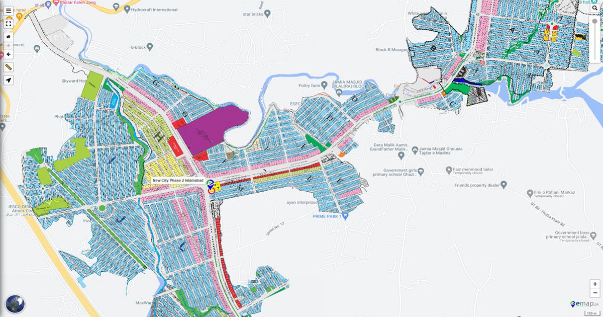
Quick answer: The New City Phase 2 map covers a multi-block residential grid in Wah Cantt, Pakistan, anchored by a 100-foot central boulevard and divided into over 20 lettered blocks (A through Y), an Executive Block, and a dedicated commercial zone. Development status varies significantly by block I Block and J Block are the most advanced, while perimeter blocks remain in early infrastructure stages.
Before you visit a plot, sign a file, or transfer funds from abroad, you need a clear picture of the New City Phase 2 map. Not a promotional brochure. A spatial breakdown. This guide gives you exactly that.
It covers the full Phase 2 block layout, directions from Islamabad and Rawalpindi, an on-site inspection checklist, and a block-by-block summary table. It is built for three types of readers: buyers trying to locate a specific block before their site visit, investors comparing development stages across the grid, and Non-Resident Pakistanis evaluating plot positions remotely from abroad.
For the full society background, developer history, and Phase 1 overview, read our New City Wah Cantt complete guide. For current plot pricing and availability by block, see our plot for sale in New City Phase 2 guide. This article covers the map and layout only no pricing, no sales language.
New City Phase 2 Map: Overview and Layout
The Spatial Axis Rule: The primary infrastructure skeleton of New City Phase 2 is anchored by a 100-foot-wide Central Boulevard running along an East-West axis. Internal residential distribution streets are standardized at 40-foot and 60-foot widths across most lettered blocks, establishing a predictable grid template throughout the layout.
Phase 2 sits adjacent to Phase 1 along the M-1 Motorway corridor near Wah Cantt and Taxila. The two phases share a boundary along Phase 2’s western edge, where Phase 1’s developed residential infrastructure transitions into the newer Phase 2 grid. The main Phase 2 entrance gate faces the link road connecting to the Brahma Bahtar Interchange approximately six minutes from the motorway exit.
The four physical boundaries of Phase 2 are:
- West: Phase 1 residential boundary
- North: Outer society perimeter wall bordering agricultural land
- East: Society perimeter wall along the far extension blocks
- South: Main link road and commercial zone frontage
The internal grid divides into lettered residential blocks (A through Y), an Executive Block positioned closest to Phase 1 and the main gate, and a commercial zone along the southern main road frontage.
Important: Map images circulating on social media forums and older property listing pages often show outdated Phase 2 boundary definitions. The block shapes, street numbering, and perimeter lines visible on pre-2024 images do not reflect current on-ground demarcation. Use only the MPCHS-stamped official layout for plot boundary reference.
[Image: New City Phase 2 Map Block Layout 2026 Official Master Block Layout Plan]
New City Phase 2 Block-by-Block Guide
Phase 2 is not a uniform grid. Development progress differs street by street, block by block. Here is a factual breakdown of every block’s position within the layout.
I Block
I Block sits in the central-to-inner zone of Phase 2, bordered by J Block to its east and internal distribution roads to its north and south. It is the most infrastructure-advanced block in Phase 2 as of 2026 road carpeting, utility ducting, and plot boundary markers are visible across most streets. Possession is available on many plots, though street-level variation exists. Plot sizes: 5 marla, 10 marla, and selected 1-kanal options.
For full pricing and street-level availability, see our dedicated I Block New City Phase 2 guide.
J Block
J Block is located immediately east of I Block, sharing a primary internal road boundary with I Block to its west. Development infrastructure is active road profiling and utility installation are visible across most streets, though possession availability varies by street number. A developing block catching up quickly to I Block’s infrastructure maturity. Plot sizes: 5 marla and 10 marla.
For full pricing and street-level availability, see our dedicated J Block New City Phase 2 guide.
Block A
Block A occupies an inner-zone position within Phase 2, adjacent to the Executive Block boundary. It is one of the earlier-alphabet blocks and sits within the more established interior of the Phase 2 grid. Development status:Developing. Plot sizes: 5 marla, 10 marla.
Block B
Block B borders Block A along a 40-foot internal road. Inner-zone placement with active listing inventory. Development status:Developing. Plot sizes: 5 marla, 10 marla.
Block C
Block C occupies a mid-inner zone position, bordered by distribution roads to its north and south. Infrastructure work is visible but not at I Block maturity. Development status:Developing. Plot sizes: 5 marla, 10 marla.
Block D
Block D sits along the northern mid-zone axis, bordered by Block C to its south and Block E to its immediate east. Road cutting and sub-base grading are active. Development status:Developing. Plot sizes: 5 marla, 10 marla.
Block E
Block E is a mid-zone block positioned between the inner and outer grid sections. Active construction visible in surrounding streets. Development status:Developing. Plot sizes: 5 marla, 10 marla.
Block F
Block F shifts toward the outer grid, with Phase 2 perimeter infrastructure in earlier stages. Development status:Early Stage. Plot sizes: 5 marla, 10 marla.
Block G
Block G occupies an outer-zone position bordering further perimeter sectors. Road profiling and boundary wall construction are the primary visible activity. Development status:Early Stage. Plot sizes: 5 marla, 10 marla.
Block H
Block H sits in the outer perimeter zone adjacent to Block G. Limited on-ground development activity visible as of 2026. Development status:Early Stage. Plot sizes: 5 marla, 10 marla.
Block K
Block K is positioned in the central-outer zone of Phase 2, bordered by lettered blocks on multiple sides. Infrastructure at sub-base stage. Development status:Developing. Plot sizes: 5 marla, 10 marla.
Block L
Block L occupies mid-outer positioning, with road profiling visible in adjacent streets. Development status:Developing. Plot sizes: 5 marla, 10 marla.
Block M and M Extension
Block M sits in the mid-to-outer zone along a north-south road axis. M Extension is a sub-sector branching east of core M Block territory. Possession status varies considerably between the main block and extension plots. Development status:Developing (M Block core),Early Stage (M Extension). Plot sizes: 5 marla, 10 marla.
Block N
Block N occupies an outer zone position with limited active inventory on secondary market platforms. Development status:Early Stage. Plot sizes: 5 marla, 10 marla.
Block O
Block O is positioned in the outer-central zone. Road cutting at initial grade stage. Development status:Early Stage. Plot sizes: 5 marla, 10 marla.
Block P and P Extension
Block P occupies a later-development outer zone position. P Extension stretches further east along the perimeter boundary. Both are in active heavy-grade infrastructure work. Not build-ready for near-term construction timelines. Development status:Early Stage. Plot sizes: 5 marla, 10 marla.
Block Q
Block Q is positioned along the outer grid axis and carries active listings on Zameen.com. Infrastructure grading visible but at early stage. Development status:Early Stage. Plot sizes: 5 marla, 10 marla.
Block R
Block R occupies a perimeter-adjacent zone within Phase 2. Road demarcation and sub-base preparation are the primary visible activities. Development status:Early Stage. Plot sizes: 5 marla, 10 marla.
Block S
Block S sits at the further reaches of the Phase 2 grid. Listed inventory exists on secondary market platforms. Suited for long-term land-banking only. Development status:Early Stage. Plot sizes: 5 marla, 10 marla.
Block T
Block T is a mid-to-outer zone sector with limited current transaction activity. Development status:Early Stage. Plot sizes: 5 marla, 10 marla.
Block U
Block U occupies outer zone positioning. Sub-grade infrastructure at active preparation stage. Development status:Early Stage. Plot sizes: 5 marla, 10 marla.
Block W
Block W is positioned along the outer boundary of Phase 2. Light infrastructure activity visible. Development status:Early Stage. Plot sizes: 5 marla, 10 marla.
Block X
Block X occupies far outer positioning within the Phase 2 perimeter. Development activity is at initial boundary demarcation stage. Development status:Early Stage. Plot sizes: 5 marla, 10 marla.
Block Y
Block Y sits at the furthest outer boundary of the lettered Phase 2 grid. Minimal on-ground construction activity as of 2026. Development status:Early Stage. Plot sizes: 5 marla, 10 marla.
Executive Block
The Executive Block is positioned closest to the Phase 1 boundary and the Phase 2 main gate making it the spatially premium sector within Phase 2. Streets are wider than standard residential blocks, boulevard widths match the 100-foot main axis standard, and proximity to the main gate provides the shortest access route into the society. The Executive Block is fully demarcated with boundary markers and active residential construction underway. Development status:Developed. Plot sizes: 5 marla, 10 marla, 1 kanal.
Commercial Zone and New City Arcade
The commercial zone runs along the southern frontage of Phase 2, directly facing the main link road. It contains retail plot allocations, commercial floor-space configurations, and the New City Arcade a dedicated commercial hub within the layout. Access from internal Phase 2 roads connects via the main boulevard intersection at the Phase 2 gate. Commercial plot sizes vary from 4 marla upward depending on zone classification.
For full commercial layout detail, see our New City Arcade guide.
New City Phase 2 Map: Block Summary Table

| Block | Location in Phase 2 | Plot Sizes | Development Status | Possession |
| Executive Block | Inner adjacent to Phase 1 boundary and main gate | 5M, 10M, 1K | Developed | Available |
| I Block | Central-inner zone | 5M, 10M, 1K | Developing | Available (street-specific) |
| J Block | Central zone, east of I Block | 5M, 10M | Developing | Partial (street-specific) |
| A Block | Inner zone, adjacent to Executive Block | 5M, 10M | Developing | Partial |
| B Block | Inner zone, borders Block A | 5M, 10M | Developing | Partial |
| C Block | Mid-inner zone | 5M, 10M | Developing | Limited |
| D Block | Northern mid-zone | 5M, 10M | Developing | Limited |
| E Block | Mid-zone | 5M, 10M | Developing | Limited |
| F Block | Outer-mid zone | 5M, 10M | Early Stage | Not available |
| G Block | Outer zone | 5M, 10M | Early Stage | Not available |
| H Block | Outer perimeter zone | 5M, 10M | Early Stage | Not available |
| K Block | Central-outer zone | 5M, 10M | Developing | Limited |
| L Block | Mid-outer zone | 5M, 10M | Developing | Limited |
| M Block | Mid-outer zone | 5M, 10M | Developing | Varies |
| M Extension | East of M Block core | 5M, 10M | Early Stage | Not available |
| N Block | Outer zone | 5M, 10M | Early Stage | Not available |
| O Block | Outer-central zone | 5M, 10M | Early Stage | Not available |
| P Block | Outer zone | 5M, 10M | Early Stage | Not available |
| P Extension | Far outer boundary | 5M, 10M | Early Stage | Not available |
| Q Block | Outer grid axis | 5M, 10M | Early Stage | Not available |
| R Block | Perimeter-adjacent zone | 5M, 10M | Early Stage | Not available |
| S Block | Far outer zone | 5M, 10M | Early Stage | Not available |
| T Block | Mid-outer zone | 5M, 10M | Early Stage | Not available |
| U Block | Outer zone | 5M, 10M | Early Stage | Not available |
| W Block | Outer boundary zone | 5M, 10M | Early Stage | Not available |
| X Block | Far outer zone | 5M, 10M | Early Stage | Not available |
| Y Block | Furthest outer boundary | 5M, 10M | Early Stage | Not available |
| Commercial Zone / New City Arcade | Southern frontage, main road | Commercial (4M+) | Developed | Available |
For current plot prices by block, read our plot for sale in New City Phase 2 guide. For I Block pricing specifically, see our I Block New City Phase 2 guide. For J Block pricing, see our J Block New City Phase 2 guide.
Contact Properties Corner to verify current block status and plot availability in Phase 2.
⚠️ BLOCK-LEVEL REGULATORY NOTICE: Do not assume that an overall society approval covers every block in Phase 2. NOC# 705/TMAH covers the New City Housing Developers project as approved by TMA Wah. Note that New City Phase 2 is an independent private layout developed by New City Housing Developers (the Chaudhry family venture) it mirrors the boulevard engineering standards of nearby B-17 but is not a CDA-administered sector and is not a direct MPCHS development. Confirm that your specific block and plot number are explicitly referenced in the approved master layout before making any payment.
How to Reach New City Phase 2: Directions and Entry Points
Getting to Phase 2 is straightforward. Here is the turn-by-turn breakdown from each major origin point.
From Islamabad: Take the M-1 Motorway westbound. Exit at the Burhan Interchange. From the interchange, follow the link road toward Wah Cantt. New City Phase 2 is approximately six minutes from the interchange exit. Watch for the New City signage on the right side of the road. The main gate faces the link road directly.
From Rawalpindi: Take the G.T. Road northwest toward Taxila and Wah Cantt. Enter the Wah-Taxila corridor and continue toward the society link road. Approximate travel time from Rawalpindi Saddar: 60 minutes. From the Wah Cantt cantonment boundary, New City is approximately 22 minutes.
From Wah City Centre: Phase 2 is a short direct drive from the cantonment area approximately 3 to 5 kilometres, under 10 minutes by car, depending on traffic at the cantonment checkpoint.
Entry Points: Phase 2 has its own dedicated main gate. This is separate from the Phase 1 entrance. Buyers frequently confuse the two. The Phase 1 gate sits closer to the established Phase 1 residential boundary. For Phase 2, continue past the Phase 1 entrance and proceed to the next gate on the link road. Confirm with the security post that you are entering Phase 2, not Phase 1, before proceeding.
For live navigation, search“New City Wah Cantt“ on Google Maps for a real-time route from your current location.
What to Check When You Visit Phase 2: An On-Site Guide
Visiting Phase 2 in person is always worth the trip. Here is what to actually look for when you arrive.
On arrival, check these physical indicators:
- Visible road sub-base or asphalt carpeting along the street of your plot this confirms street-level development progress
- Utility conduit pipes or electrical pole installations along street boundaries these indicate utility infrastructure is active on that street
- Concrete boundary walls and plot-corner peg markers these confirm physical demarcation has been completed for that plot
- Active construction on neighbouring plots this signals block-level momentum and resale demand
Confirming your specific plot location:
Cross-reference your plot file number against the physical numbered markers installed by the society at street intersections. Do not rely solely on an agent pointing to a section of ground. Your allotment letter will carry your plot number and block name match those against the MPCHS map markers on-site before signing any transfer documents.
Documents to bring on your site visit:
- Allotment letter (original or certified copy)
- Plot number and block name (printed)
- MPCHS-stamped Phase 2 block map (current 2026 version)
⚠️ ON-GROUND PLOT DEMARCATION NOTICE: Do not purchase a plot file based solely on a master map drawing. Ground boundaries shift slightly during physical road cutting phases. Always obtain an official, society-stamped plot demarcation document showing actual corner pegs and physical street measurements before completing a secondary market transaction.
For NRP buyers who cannot visit in person: Properties Corner agents visit New City Phase 2 regularly. They can provide a verified video walkthrough of your specific plot and street, confirm possession status, and validate on-ground progress against your allotment letter before you commit funds from abroad.
Properties Corner agents visit New City Phase 2 weekly book a remote plot verification today.
Know the Layout Before You Move
TheNew City Phase 2 map covers a large, multi-block territory and not every part of it is at the same stage. That is the single most important thing to understand before you visit or invest. Early blocks like the Executive Block and I Block are mature. Outer perimeter blocks are in active heavy infrastructure work. Knowing which is which saves you from misreading a file’s value or arriving at a site visit without the right expectations.
Use this article as your starting point. Then go deeper where you need to. For plot prices and secondary market rates, the plot for sale in New City Phase 2 guide has the numbers. For I Block specifics, the I Block New City Phase 2 guide covers pricing, possession, and street-level detail. For J Block, the J Block New City Phase 2 guide does the same. Understanding the New City Phase 2 map is the first step everything else follows from here.
Browse current Phase 2 listings on Properties Corner
Book a free consultation with our Phase 2 specialists
Our agents know every block in Phase 2 speak to us before you visit or sign anything.
Frequently Asked Questions
Where is New City Phase 2 located?
New City Phase 2 is located in Wah Cantt, Punjab, Pakistan, adjacent to the M-1 Motorway between Islamabad and Peshawar. The society sits near Taxila and is approximately six minutes from the Burhan Interchange. It is accessible from both G.T. Road and the M-1 Motorway via the Brahma Bahtar Interchange link road.
How many blocks are in New City Phase 2?
Phase 2 contains over 20 lettered residential blocks running from A through Y (with some letter variations), plus an Executive Block and a dedicated commercial zone. Extension sub-sectors including M Extension and P Extension bring the total number of distinct block designations to approximately 27. Each block carries its own development timeline and possession status.
Which block is the most developed in New City Phase 2?
The Executive Block is the most infrastructure-mature sector in Phase 2, with completed road surfacing, utility connections, and active residential construction. I Block is the most advanced among the standard lettered residential blocks road carpeting, utility ducting, and plot boundary markers are in place across most streets, and possession is available on many plots. J Block follows at a slightly earlier but rapidly progressing stage.
How do I get to New City Phase 2 from Islamabad?
Take the M-1 Motorway westbound from Islamabad and exit at the Burhan Interchange. From the interchange, follow the link road toward Wah Cantt. New City Phase 2’s main gate is approximately six minutes from the interchange. Search “New City Phase 2 Wah Cantt” on Google Maps for live turn-by-turn navigation from your current location. Refer to the full directions section above for route options from Rawalpindi and Wah City Centre.
Is there a map available for New City Phase 2?
The official MPCHS-released Phase 2 block layout map is referenced and embedded earlier in this article. Note that older versions of the Phase 2 map circulating on social media, property forums, and listing platforms frequently show outdated block boundaries and street configurations. Use only the current 2026 version for plot boundary reference confirm it carries the official MPCHS stamp before using it as a transaction document.