
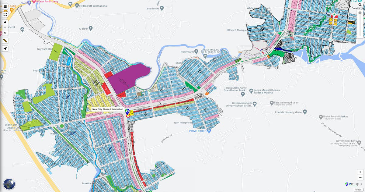
Investing in a new housing development is an exciting journey, and understanding its layout is the first step toward making a confident decision. A detailed plan, especially a new city phase 2 map, serves as your comprehensive guide to the future of the community. This document is more than just a drawing; it’s a blueprint that reveals the location of residential plots, commercial areas, parks, and essential infrastructure. By learning how to interpret this map, you can gain valuable insights into the long-term value of your potential investment and envision the lifestyle it offers. This guide will walk you through reading and understanding the key elements of a Phase 2 map, empowering you to make an informed choice.
What a Phase 2 Map Typically Covers
A Phase 2 map outlines the expansion of a new urban development, building upon the foundations laid in Phase 1. While the initial phase usually establishes the main entrance, core infrastructure, and initial residential blocks, Phase 2 often introduces a wider range of amenities and property types. Developers use this stage to enhance the community’s appeal and functionality.
Typically, a Phase 2 map details:
- New Residential Sectors: These are new blocks or clusters of plots, often with different size options.
- Expanded Infrastructure: This includes the extension of road networks, utilities like water and electricity, and advanced drainage systems.
- Community Amenities: Look for the allocation of land for parks, schools, mosques, hospitals, and community centers.
- Commercial Zones: These areas are designated for shops, offices, and other businesses, indicating future economic activity.
Reading the Map Legend
Every map comes with a legend, or key, which is essential for interpretation. This small box translates the symbols, colors, and patterns on the map into meaningful information. Before you try to locate a specific plot, take a moment to study the legend. It provides the crucial context needed to understand the entire master plan. The new city phase 2 map legend will typically define various elements, such as different colors for residential, commercial, and amenity plots. It will also clarify symbols for infrastructure like grid stations, water towers, and public transport stops. Understanding these symbols helps you see how the different parts of the community connect and function together.
Zoning and Land-Use Insights
Zoning is how urban planners allocate land for specific purposes. A Phase 2 map will clearly show these designated zones, providing a clear picture of the community’s structure. You will see large areas marked for residential use, often subdivided by plot sizes. Other sections will be marked as commercial districts, reserved for future retail and business activities.
Pay close attention to mixed-use areas, which combine residential and commercial functions, creating vibrant, walkable neighborhoods. Equally important are the green spaces. The map will show the location and scale of parks, playgrounds, and other recreational areas. The balance between developed land and green spaces is a strong indicator of the quality of life the project aims to deliver. A well-planned community will have a harmonious mix of all these zones.
Transport and Connectivity
How you move around a community is fundamental to your daily life. The Phase 2 map details the entire transportation network. Look for the road hierarchy, which includes main boulevards, collector roads that link different sectors, and smaller residential streets. A well-designed network ensures smooth traffic flow and easy access to all parts of the development.
The map will also highlight connectivity to areas outside the project, such as access to major highways or arterial roads. Check for planned public transport routes or stations, as these are crucial for long-term convenience and can significantly boost property value. Additionally, many modern plans include dedicated pedestrian networks and cycling paths, promoting a healthy and sustainable lifestyle for residents.
Utilities and Social Infrastructure
A successful community relies on robust infrastructure. Your new city phase 2 map should provide clear information about the location of essential utilities and social amenities. Look for the placement of electrical grid stations, water treatment plants, and sewerage systems. Their strategic placement ensures that all plots receive reliable services without disrupting the residential environment.
Social infrastructure is just as important. The map will allocate land for schools, hospitals or clinics, and places of worship. The proximity of your plot to these facilities can be a major factor in your decision. A development that integrates these amenities thoughtfully into its master plan shows a strong commitment to creating a self-sufficient and family-friendly community.
Plot Information and Buying Tips
Once you understand the broader layout, you can focus on individual plots. The map will display plot numbers and often categorizes them by size (e.g., 5 marla, 10 marla, 1 kanal). When evaluating a plot, consider its location relative to the features you’ve identified.
Here are a few practical tips:
- Corner Plots: Often considered premium due to having open space on two sides.
- Park-Facing Plots: Ideal for families and those who value green views.
- Proximity to Commercial Areas: Convenient, but consider potential noise and traffic.
- Main Boulevard Plots: Offer excellent access but may experience higher traffic flow.
Think about your personal preferences. Do you prefer a quiet street or easy access to main roads? Being near a park might be a priority, while another buyer might prefer being close to the commercial district. Use the map to find a plot that aligns with your long-term goals.
Sustainability and Future-Proofing
Modern urban planning emphasizes sustainability and resilience. A forward-thinking Phase 2 map will reflect this through its design. Look for features like rainwater harvesting systems, planned green belts that act as natural buffers, and the use of sustainable materials in public infrastructure. The layout of streets and buildings may also be optimized for natural light and ventilation, reducing energy consumption. A developer’s commitment to these principles not only benefits the environment but also enhances the long-term value and livability of the community.
Conclusion
The new city phase 2 map is an indispensable tool for any prospective buyer. It offers a transparent and detailed vision of the community’s future, allowing you to move beyond the sales pitch and analyze the development’s fundamentals. By carefully studying the map legend, zoning, infrastructure, and plot locations, you can assess the project’s long-term potential and find a property that perfectly suits your needs. A thoughtful review of the master plan empowers you to invest with confidence, knowing you have a clear roadmap to the home and lifestyle you desire.
Frequently Asked Questions (FAQs)
1. Where can I find the official new city phase 2 map?
You can typically obtain the official map from the developer’s main office, their official website, or an authorized sales agent. Always ensure you are viewing the most current and approved version to avoid making decisions based on outdated information.
2. What do the different colors on the new city phase 2 map mean?
The colors represent different land-use zones. For example, yellow might signify residential plots, blue for commercial areas, and green for parks and open spaces. Always refer to the map’s legend or key for precise definitions, as color codes can vary between projects.
3. Does the new city phase 2 map show future development plans?
Yes, the map is a blueprint for future development. It shows not just the current plots for sale but also the planned locations for future amenities like schools, hospitals, commercial centers, and parks that will be built as the community grows.
4. Can the new city phase 2 map change over time?
Minor adjustments can sometimes occur due to technical requirements or planning updates from municipal authorities. However, the core master plan, especially regarding major infrastructure and zoning, is generally fixed after receiving official approval. It’s best to confirm the map’s approval status with the developer.
5. How can I use the new city phase 2 map to choose the best plot?
Use the map to identify your priorities. Determine if you prefer a plot near a park, a school, or a main road. Consider factors like plot size, corner or park-facing options, and distance from commercial zones. The map allows you to visualize your daily life in the community and choose a location that fits your lifestyle.